As I write this, I sit in awe over what the past 3 days have held.
Stag Saddle- the tallest point on the TA- and the memory of camping on top of it is burned in my brain like a memory I can never forget. Flashes of color float in my mind as I remember the sunset and sunrise.

But first, let’s catch up from where we left off.
Originally, we planned to spend 2 days in Methven. But Jeremy got sick and we weren’t about to head into the mountains with a cold. So we waited…
We were graciously offered a place to stay just outside of Christchurch with a ‘trail angel’ while Jeremy recovered.
Trail angels are people who are willing to help trampers along their journey. On the TA most trail angels offer a spare room or a place to camp if you need some time to recover.
Mich and Lisa were our angels and they welcomed us with open arms into their home for a day. Mich even picked us up from where we were (about one hour drive one way). Their kindness left a lasting impression on me. They opened up their home to two strangers (one sick) and made us feel so welcome! To put the cherry on top, they were both nurses! Just who you want to have close by when you’re sick.

6 March, 2026 (Day 42)
To get to the start of two thumbs track, you have to take a shuttle via bus from Geraldine to bypass the Rangitata River. This river is a large braided river that, under perfect conditions, takes about 2 hours to cross. Any influx in water and you can easily be stranded in the middle, finding sections impassable. For safety, we decided to not try to cross the river but get a shuttle from town.
As we bounce along the gravel road towards the trailhead, the van fills with dust so thick we can barely breathe. The driver seems to be perfectly fine with driving down the road at 40-50 miles per hour as the dust kicked up enveloped the van.

When we finally arrive I plunge out of the van gasping for air and nauseous.
The Two Thumbs track begins following a narrow river. I forget how many times we had to cross the river to be able to walk along the bank. The steep cliff walls cut us off at every twist of the river, and every time we thought we knew where the trail was- it would disappear again!


Finally we began to climb up, out of the valley. Stunning mountain landscapes surround us as we reach the first hut and decide to stop for the night.


As we drifted off to sleep, we were startled by the sounds of Kea flying all around and swooping down only feet away from our tent. They tirelessly chirp their loud call over and over again. Finally, we are sure that our clothing and food are not part of their dinner meal plan and fall sound asleep.

7 March, 2026 (Day 43)
The Kea call us to wake up, just like you would expect a rooster to if you lived on a farm.
Jeremy brews a pot of coffee and we watch the sun rise on the world, Kea shuffling all about.
We are the second people to leave camp and get an early start before the sun begins to roast our backs. We climb over the first large saddle we have to summit.


At the summit we stop for a quick snack break and head down again. Our feet are never dry on this trail and we follow a river through the valley to a hut where we have lunch.

After lunch we hastily head to the next hut while listening to the audio book of “The Hobit”. We planned to end our day at the next hut, but an idea has crept into our minds… what if we carry on, up the next saddle and camp at the top?
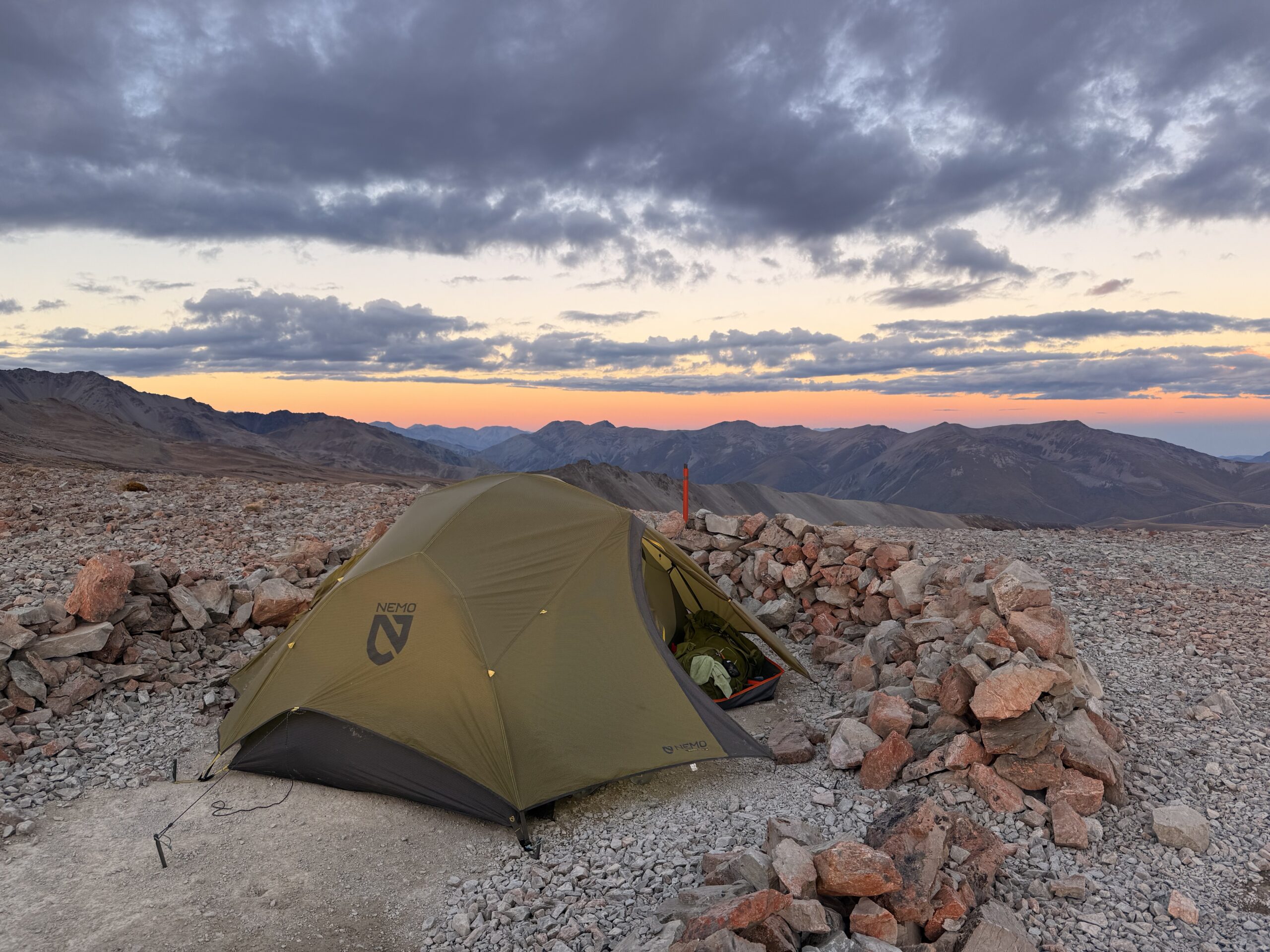
The DOC sign says it will add 3.5 hours to our day, but we carry on anyway. We begin our climb to Stag Saddle – the tallest point on the TA around 4 PM. We arrive around 7:30 PM in fantastic spirits. It’s been a long day of 13 miles and over 5,000 feet climbed.


The sun fades into fantastic hues of pink and orange over the western mountains as the eastern mountains come alive with alpenglow. We set up our tent next to a sign stating “Stag Saddle – Altitude 1925m – The highest point on the TA”


I prayed for a calm clear night, with no wind to keep us awake. I don’t think there has been a more calm, quiet night all of trail.
8 March, 2026 (Day 44)
The Milky Way is fully visible from up on the mountain and we watch as the most brilliant bright red sunrise begins to emerge.


After enjoying multiple cups of coffee and a photo shoot we pack up and head from our high perch across the ridge to a full breathtaking view of the southern alps. We arrive just in time to see Mount Cook (the tallest mountain in New Zealand) snow-capped in all its glory before it gets engulfed in clouds 10 minutes later.

We can see the predicted weather moving in from a distance but for now it’s nice and sunny.
We slowly make our way along the ridge, treasuring every moment as the ridge heads down towards the valley. Eventually the trail leads back down to the valley and we are following the river again.
Let’s review today’s score :
women-hood = 1 / Jess = 0
Today is one of those days where womanhood strikes and it leaves me feeling slow, achy, and out of energy. All the ladies reading this blog know what I’m talking about 😉
Jeremy is quick to step in and help. Let’s just say, chilvery is not dead!!! I am very grateful to have a life partner to not only carry my load physically, but someone willing to help in every way ❤️

We have lunch in a cute hut built in the late 1800s and told ourselves we will walk until we get tired and then make camp. We make it a whopping quarter of a mile and make camp beside the river 😂
Tonight we try a new recipe for chocolate chia seed pudding and chill it in the river. It’s delicious!!! Chocolatey goodness on trail is a real treat!

We sleep soundly with full belly’s as the rain begins to come down.
We will have to worry about the rain tomorrow, but for now we are tucked away in our little 2 person ‘home’- snuggled up and warm.
9 March, 2026 (Day 45)
We arrived in Lake Tekapo cold and wet. We set up our tent at the holiday park in town and made a mad dash for the hot showers.

Now it’s a long list of things to get done this afternoon – laundry, charging all our devices, grocery shopping, and making arrangements for our next section.
With all that in mind, I’ll leave you with a final clue to our next section – tomorrow we aren’t walking, we are biking!!!
Thanks for reading The Adventure 💙